A Delft team won the Transport Prize in the Data for Development (D4D) Challenge. They showed how to use mobile phone data to optimise road planning.

The idea behind the D4D Challenge by telecom provider Orange is to use big data usage techniques in developing countries to achieve sustainable development. This concept is supported by the United Nations. The D4D competition called for projects in energy, health, agriculture, national statistics and transport. The TU Delft team, consisting of master’s student Yihong Wang, Assistant Professor Dr Gonçalo Correia and Professor Erik de Romph from the Department of Transport and Planning (CEGS), came out as winners of the Transport Prize.
The competition focussed on the West African nation of Senegal that faces growth in population, economy, urbanisation and traffic. The World Bank stated that population growth was outstripping road development, and that was ten years ago. There exists an urgent need for new roads and for upgrading existing roads. But the question is where? The scarcity of funds makes that question in Senegal even more urgent than in EU countries.
When planning new or upgraded infrastructure, the first thing that transport planners will want to know is the demand of travel between areas. They calculate that with a ‘gravity model’. This says that the number of travels between two areas A and B is proportional to the numbers of people in A and in B, divided by the effort it takes to travel between A and B.
“In the Netherlands and other EU countries, most of these data are readily available”, said De Romph. “In Africa however, even the most basic statistics are lacking.” Now, wouldn’t it be great if you could use mobile phone data instead of national statistics? The good news is that the TU Delft team has shown that they can indeed derive relevant transport data from Call Detail Records (CDR’s) as provided by Orange over the year 2013.
Cell phone networks have quickly spread over Senegal with over nine million customers (from a population of 13,6 million) and 1666 antennas spread over the country 4.7 times bigger than the Netherlands. One dataset on cell phone interaction data showed which antenna was connected to which during a telephone call or an SMS. The data represented anonymised phone traffic between places that functioned as an indication of the demand for transport in between. The other data set trailed the top 10 % most frequent callers and tagged their approximate location to the antenna carrying the signal. These data produced an estimate of how many people travelled and where they went.
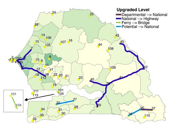
These GSM traffic data were used in a road network model to determine where upgrades or new roads are most effective. There is an element in choice involved here. The team decided to improve accessibility first in the least accessible regions. The result is a map showing new roads (light blue) east and west and two major upgrades (dark blue) at both sides of the country.
De Romph believes that not only are telephone data perfectly suitable to understand and predict mobility patterns, but also they may be better than the conventional statistics. “In Africa you may see two large cities close to each other and yet, there is very little interaction between them. This lack of interaction may be due to cultural or religious differences. The deficit of phone traffic between the cities will tell you, there will be little demand for traffic in between and investments will be more effective elsewhere.”
–> Erik de Romph, Gonçalo H.A. Correia, Yihong Wang: National and Regional Road Network Optimization for Senegal Using Mobile Phone Data.
Do you have a question or comment about this article?
delta@tudelft.nl
Comments are closed.