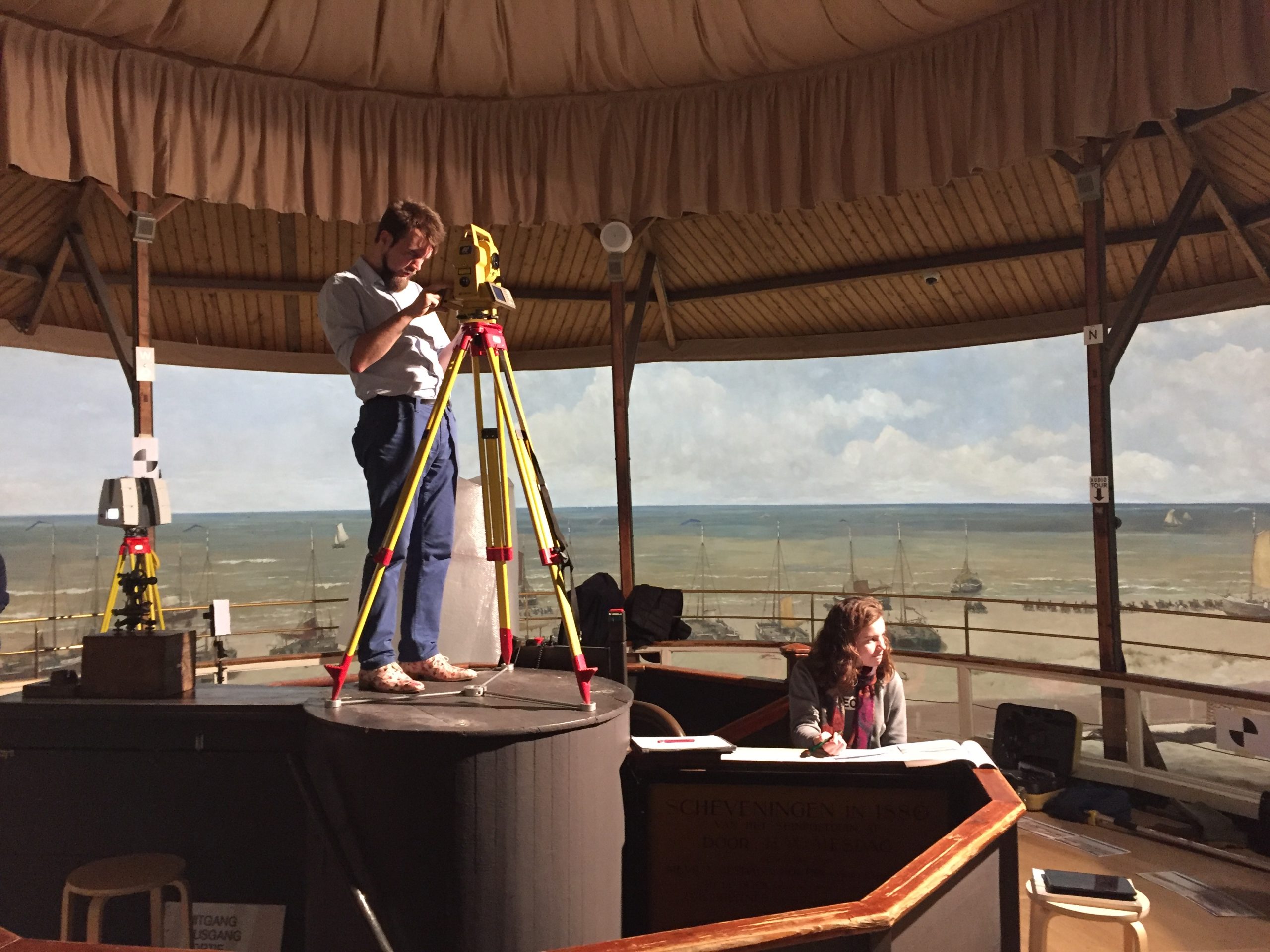
Delft scientists worked out exactly where Mesdag stood in Scheveningen when he painted his famous sea scape in 1880. Their work is exhibited in the Panorama Mesdag Museum.
The researchers placed a theodolite right in the centre of the canvas. (Photo: Ramon Hanssen)
Panorama Mesdag is a panorama painted by Hendrik Willem Mesdag completed in 1881. Situated in a purpose-built museum in The Hague, the panorama is a cylindrical painting more than 14 metres high and about 40 metres in diameter. From an observation gallery in the centre of the room, the cylindrical perspective creates the illusion that the viewer is on a high sand dune overlooking the sea, beaches and the village of Scheveningen in the late 19th century.
Mesdag did paint the sea scape from a high dune, a dune called Seinpostduin. But what exactly were the coordinates? The dune doesn’t exist anymore. The vantage point should be located somewhere inside a newly built apartment block, or so it was presumed for years.
The vantage point is right on the pavement
But according to Delft researchers, who performed a land surveying experiment, the actual location is in front of an adjacent house, right on the pavement. The Panorama Mesdag Museum is now in discussion with the municipality to place a monument at that exact spot.
The land surveying experiment was performed by Prof. Ramon Hanssen of the Mathematical Geodesy and Position department (CEG Faculty) and several of his students. The project is part of a special exhibition in the Panorama Mesdag Museum in collaboration with TU Delft Library about land surveying techniques from the past and present.
Pinpointing the exact location was quite a puzzle. At some point during the research, it seemed Mesdag had to be standing in the surf when he made the sketches for his panorama. Another simulation placed him right in the centre of The Hague. In sum, the computer programme Ramon Hanssen used to determine Mesdag’s position seemed to be going berserk when he fed the software with the coordinates of several reference points and accompanying angles.
The researchers placed a theodolite right in the centre of the canvas. This is a precision optical instrument for measuring angles between designated visible points in the horizontal and vertical planes. Some clearly visible and recognisable landmarks on the painting that still exist today, such as the lighthouse, the water tower and the Oude Kerk (church spire), served as reference points.
Mesdag forgot 10 degrees
From the measurements of angles one can calculate distances using triangulation, a technique that has been known for centuries. Hanssens computer should have easily figured out the exact position.
But as it turned out, Mesdag did in fact not depict a perfect 360 degree view. He forgot 10 degrees, which in the painting corresponds to a three meter wide piece of canvas. Either that or he just took some artistic licence. He probably skipped a piece of ocean. Since the painting is a perfect circle, another part of the landscape is slightly stretched. The stretched part lies to the north east of Scheveningen, where Mesdag might have wanted to highlight several buildings. Taking this omission into account, all reference points in the painting suddenly matched reality almost perfectly.
So what is most remarkable about this finding? The fact that three metres is missing? “No, I would say that we demonstrated the stunning precision with which Mesdag painted,” says Hanssen. “If you incorporate these three metres, everything falls into place.”
TU Delft’s role in the 19th century
The exhibition in the museum kicks off with this surveying project. The history of land surveying is subsequently shown using measuring instruments, drawings and historical maps from the TU Delft collection. Scientific photos show the highest points on the landscape, including spectacular temporary constructions that were specially built for surveying the land. Visitors can also stroll through digital and interactive maps that show how the landscape has constantly changed from Mesdag’s time to today.
The exhibition also nicely shows the important role TU Delft played in the 19th century when it came to land surveys. In 1861, the German Empire asked the Netherlands to participate in a European Grande Measurement. This was a huge scale land survey, stretching from Scandinavia to Sicily, aimed at gaining greater understanding of the shape and size of the earth. In the Netherlands, most measurements were made by professors and students of the Polytechnic School in Delft (the predecessor of TU Delft).
- Exhibition From the Highest Point: Land surveys in the time of Mesdag is in collaboration with TU Delft and is on display at Panorama Mesdag from 31 March to 22 September 2019.
- Panorama Mesdag, Zeestraat 65, The Hague, info@panorama-mesdag.nl
Do you have a question or comment about this article?
tomas.vandijk@tudelft.nl


Comments are closed.