The Netherlands is sinking faster than previously thought. This is what a team of researchers led by Ramon Hanssen of the mathematical geodesy and positioning section found.

The peat and clay areas in the west of the country can now be accurately measured. (Photo: Wikimedia commons)
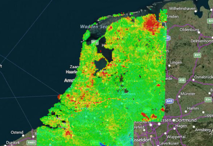
Ramon Hanssen’s team incorporated three different types of measurement data into a model – satellite radar, GPS, and gravity measurements – and developed an interactive map which can be found on the bodemdalingskaart.nl website.
Causes of the observed soil subsidence
Because the map shows the location of oil and gas fields in addition to the different soil types in the Netherlands, it is in some cases possible to see the cause of the observed soil subsidence. The map is kept up to date with new satellite measurements every day. This makes it possible to keep track of, for example, land subsidence in relation to gas extraction in Groningen and the effects of reduced extraction.
The map is allowing researchers to distinguish between the deep causes of soil subsidence, such as gas extraction, and their effects on the upper few metres for the first time. The latter could not be measured directly until now. As it turns out, in many places in the western part of the country especially, ‘shallow’ subsidence is greater than the better known ‘deep’ subsidence. The peat and clay areas in the west of the country can now be accurately measured.
‘It may mean the end of the characteristic Dutch landscape with meadows, cows and windmills’
Climate change seems to be playing a major role in this accelerated subsidence. The relatively warm summers are drying out peat soil more, resulting in faster soil sinking. This is an irreversible process that in turn is contributing to climate change – as the peat dries it oxidises, releasing more CO2 into the atmosphere.
Hanssen says that “if soil subsidence continues at current rates, it may mean the end of the characteristic Dutch landscape with meadows, cows and windmills and huge damage to the historic city centres.”
However, there is also good news. Water boards can use the measurements to handle their water level management more effectively by being able to better anticipate periods of drought.
Do you have a question or comment about this article?
tomas.vandijk@tudelft.nl
Comments are closed.