An analysis of Hurricane Harvey casualties has shown that most drowned in or around cars. A revision of flooding maps is due, the researchers say.

(Photo: jim gade / Unsplash)
Researchers from TU Delft and Rice University Texas have studied the circumstances of 70 casualties who died as a result of Hurricane Harvey which made landfall in Texas on August 25th 2017. The wind was less of a problem than the unprecedented rainfall. In a four-day period, many areas received more than 1,000 mm of rain, causing immense floods that inundated hundreds of thousands of homes, displaced more than 30,000 people, and prompted more than 17,000 rescues. By comparison, the Netherlands has an average annual rainfall of 800 mm.
Researchers used official government sources and media reports to build a database of flood casualties, listing age, gender, location and time of recovery, and circumstances of death. The major cause of death was drowning (81%) and a large proportion of these (29%) drowned in or near vehicles. “A significant proportion of the fatalities drowned when driving a vehicle into floodwaters or getting swept away by the current while getting out of the car (confirmed for 21 of 57 drowning fatalities)”, the researchers explain.
 A motorist near A Street in Lincoln, NE attempts to drive through a flooded area. Several stranded motorists were rescued after attempting to cross flooded roads. (Photo: Eileen Williamson / Flickr)
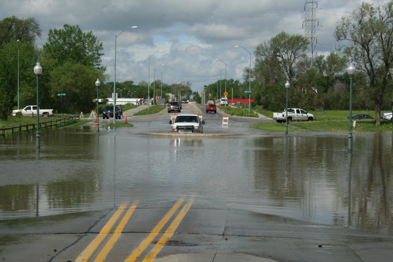
Hydraulic engineer, Maartje Godfroy, says that low-water crossings are notoriously dangerous. When a rising river flows over the bridge, driving across it is a major hazard. Cars get swept off the bridge with astonishing ease. “Preventive closing of these crossings during future events could be considered,” the authors suggest. Godfroy adds that people are generally well aware of the risk thanks to the campaign ‘Turn around, don’t drown’. Still, it’s easy to underestimate the power of moving water.
Godfroy and Professor Bas Jonkman also noticed that most of the fatalities occurred outside the designated flood areas. Maps of areas with a flooding risk of 1% or 0.2% per year are compiled by the Emergency Management Institute, FEMA. Should these maps be revised? The researchers say that the flood risk maps are based on either rain or high sea levels, and not on the combination of these as may occur during a hurricane.
On the other hand, says Godfroy, Harvey was an exceptional hurricane that went way beyond a one-in-500-year chance. Harvey has shown that living outside a designated flood area doesn’t mean you’re out of danger.
When asked if there are any lessons to be drawn from the analysis of Hurricane Harvey for the Netherlands , Godfroy says that the Dutch risk tolerance is much lower (up to once in 10,000 years for seawalls), but that Americans are very strong in self-reliance, mutual help, and setting up rescue missions.
- Sebastiaan Jonkman, Maartje Godfroy, Antonia Sebastian and Bas Kolen, Brief Communication: Loss of life due to Hurricane Harvey, Natural Hazards and Earth System Sciences, 19 April 2018
- Read also: Hurricane Harvey heralds the ‘new normal’
- Link to the Hurricane Harvey Report (October 2017)
Do you have a question or comment about this article?
j.w.wassink@tudelft.nl
Comments are closed.