Het duurzame zeiljacht Ecolution van Prof.dr. Wubbo Ockels is door vandalen tot zinken gebracht. Dat heeft de politie in Groningen vanochtend bekend gemaakt.
‘Aanval op symbool duurzaamheid’
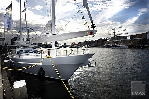
Het schip is woensdagochtend gezonken aangetroffen. Het jacht lag bij scheepswerf No Limit Ships in Groningen, dat de techniek aan boord verzorgd heeft. Ecolution ligt daar op de bodem van het Reitdiep, maar is zo hoog dat het nog wel boven het water uitsteekt.
Volgens Erik Ploeger, van de werf Marvis die het schip heeft gebouwd, hebben vandalen afsluiters (‘sealings’) rond de schroefassen weggetrokken waardoor het schip water maakte. Doordat ook aan de voorzijde afsluiters zijn losgetrokken, gaat men uit van opzet. “Een leek zou het zo niet doen”, meent Ploeger.
De Ecolution heeft vele miljoenen gekost en is uitgerust met de nieuwste technieken op duurzaamheidsgebied. Het schip kan al zeilen elektriciteit opwekken met propellors onder de boot die door de stroming worden aangedreven.
De politie heeft geen idee wie of welke organisatie groepering voor de actie verantwoordelijk is. Het is niet bekend of de Ecolution gerepareerd kan worden. Burgemeester Peter Rehwinkel van Groningen sprak op Twitter van een ‘aanval op symbool duurzaamheid’.
Website over het schip:
http://www.ecolutions.nl/
,Update
Het Dagblad van het Noorden meldt dat Ockels 5.000 euro beloning uitlooft voor de tip die leidt naar de dader(s). Ockels is er van overtuigd dat er sprake is van een aanslag. “Het was een doelgerichte actie om het schip tot zinken te brengen.” In overleg met de politie zegt Ockels niet wat er precies gebeurd is.
Ruud Kooistra, werkzaam bij Tendris, een organisatie die duurzame producten ontwikkelt, looft eveneens een beloning van 5.000 euro voor de juiste tip uit. Dat zei Ockels zonet tegen 1TV.
Initially the Grace satellite data were a bit disappointing. The gravity recovery and climate experiment satellites became operational in March 2002, revolving around the Earth in a north-south direction, sensing the gravitational pull of the Earth by measuring the variation of the distance between the satellite pair. The distance between them was typically a few hundred kilometres, the variation only a few micrometers – hundred thousand times million times smaller. But when results of subsequent passes were compiled to arrive at a gravity atlas of the world, broad noisy bands spoiled the picture.
“It was the result of changed circumstances at the Earth surface – like for example the tide had changed”, explains dr Bert Wouters, who defended his thesis last Tuesday at the faculty of Aerospace Engineering (AE). The different amounts of water meant a variation of the local mass, and hence another gravity value. “Of course people at Nasa and DLR [German Aerospace, ed.] have foreseen the effect, but the correction they applied couldn’t take the noise bands away”, Wouters says.
So the Delft engineer set out to design a filtering algorithm himself, called EOF or ‘empirical orthogonal function’, making use of the by then large existing dataset consisting of six years worth of measurements. This allowed Wouters to filter out measurements with the same periodicity in time. The shortest periods are those of the ocean tides, while seasonal variations are longer and ocean currents have a longer periodicity still. Selecting measurements with the same periodicity and rejecting others allowed him to get rid of ‘non-coherent’ signals – another word for ‘noise’. Needless to say this involved massive amounts of number crunching, putting elaborate datasets through impressive mathematical formulas. The work even led to a proposition in his thesis: “Gathering scientific observations is a sleep-inducing and time-consuming activity, what is flagrantly ignored by the end-user of the data.” Indeed, the resulting gravity atlas looks disturbingly normal.
The filtered data allowed the melting of Greenland’s land ice to be measured directly for the first time. Wouters published his findings, together with dr. Ernst Schrama (AE), in the October 2008 issue of Geophysical Research Letters. They showed that between 2003 and 2008 Greenland had lost on average 195 cubic kilometres of land ice per year – enough to raise the oceans worldwide by 0.5 millimetres. Their publication drew a lot of attention. ‘Greenland ice loss behind a sixth of sea level rise,’ wrote New Scientist.
Until the late 1990s, sea level rise was solely caused by the expansion of warming seawater. It was only in the early 2000s that melting land ice started to contribute as well, and now both causes are equally large. Melting ice from Greenland, Antarctica and glaciers adds 1.5 millimetres per year to the sea levels. Another 1.5 millimetres comes from the thermal expansion.
‘The synergy between Grace data (…) and regional climate models (…) promises a leap forward in our understanding of the mass balance of the ice sheets’, Wouters writes in his thesis. He refers to the collaboration he has set up with climate modellers from the institute of marine and atmospheric research Utrecht (IMAU), which is part of Utrecht University. IMAU has developed a model for the Greenland ice sheet based on the temperature data of the last fifty years. The predictions it has produced for ice loss in recent years were within range of the measurements from GRACE data. “This means that their model is basically correct, and they can start predicting ice sheet loss for the next 20-30 years”, Wouters explains.
The ability to monitor ice sheets from space is not guaranteed, however. The Grace mission is still active but long overdue. The Goce satellite, aimed at producing a more detailed gravity map, is expected to have a much shorter life span because of its reduced altitude.
Bert Wouters: Identification and Modelling of Sea Level Change Contributors, On Grace satellite gravity data and their applications to climate monitoring. January 19, 2010.
 ‘Aanval op symbool duurzaamheid’
‘Aanval op symbool duurzaamheid’
‘Aanval op symbool duurzaamheid’
De sabotage is gisterochtend ontdekt. Het jacht ligt aan de kade bij scheepswerf No Limit Ships in Groningen, dat de techniek aan boord verzorgd heeft. Ecolution staat daar met de kiel op de bodem van het Reitdiep, maar ligt nauwelijks dieper dan de waterlijn.
Volgens Erik Ploeger, van de werf Marvis die het schip heeft gebouwd, hebben vandalen afsluiters (‘sealings’) rond de schroefassen weggetrokken waardoor het schip water maakte. Doordat ook aan de voorzijde afsluiters zijn losgetrokken, gaat men uit van opzet. “Een leek zou het zo niet doen”, meent Ploeger.
De Ecolution heeft vele miljoenen gekost en is uitgerust met de nieuwste technieken op duurzaamheidsgebied. Het schip kan al zeilen elektriciteit opwekken met propellors onder de boot die door de stroming worden aangedreven.
De politie heeft geen idee wie of welke organisatie groepering voor de actie verantwoordelijk is. Het is niet bekend of de Ecolution gerepareerd kan worden. Burgemeester Peter Rehwinkel van Groningen sprak op Twitter van een ‘aanval op symbool duurzaamheid’.
Website over het schip:
http://www.ecolutions.nl/
Update
Het Dagblad van het Noorden meldt dat Ockels 5.000 euro beloning uitlooft voor de tip die leidt naar de dader(s). Ockels is er van overtuigd dat er sprake is van een aanslag. “Het was een doelgerichte actie om het schip tot zinken te brengen.” In overleg met de politie zegt Ockels niet wat er precies gebeurd is.
Ruud Kooistra, werkzaam bij Tendris, een organisatie die duurzame producten ontwikkelt, looft eveneens een beloning van 5.000 euro voor de juiste tip uit. Dat zei Ockels zonet tegen 1TV.
Zie ook de website van Dagblad van het Noorden voor foto’s
Wereldomroep
“Duurzaam Nederland heeft sterkere vechtershouding aangenomen tegenover niet-duurzaam Nederland”, aldus Ockels bij de Wereldomroep over de aanslag op zijn schip.
Heb je een vraag of opmerking over dit artikel?
delta@tudelft.nl
Comments are closed.